Meanwhile, back at the ranch…

Amargosa Desert

Amargosa Desert

I have to apologize, dear reader, for neglecting this blog all week, but we have been very busy helping Wanda’s daughter Lana prepare for moving. She and her husband Lew are moving to Boca Raton to help care for Lew’s mother, who is recovering from a stroke and whose husband died last month. Lana and Lew have been planning to move to Israel next year some time, but this new development has all gone down very quickly. She just came back from the funeral last week, Lew will fly back this evening and they are planning to hit the road for Florida next Wednesday!

So we have been helping get rid of stuff all week – the guy at the dump is beginning to think of us as family and the lady at the Salvation Army has seen quite enough of us, thank you very much.

Our first task was to fill, and I do mean “fill”, our car and top carrier with house plants, a fifteen gallon aquarium and a couple of pots of very unhappy fish (How do you tell if a fish is unhappy? I can’t explain it, but you can tell.) and take them to a former co-worker in the Amargosa Desert. Lana and Lew have both worked there at Horizon Academy, a school for wayward youth, in recent years.

Haven’t got time to finish this – the dump beckons. Some pictures:

Lana's home

Lana's home

Pahrump from limestone hi

Pahrump from limestone hi

Mountain with bajad

Mountain with bajad

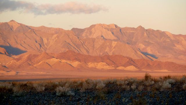
The Funeral Mountains at sunrise

The Funeral Mountains at sunrise

Posted in Basin & Range, Desert, Mountains, Travel | Leave a comment

Fallon to Pahrump, cont.

Black Mountain

"Black" Mountain

We made it to Pahrump without major incident. It was a beautiful sunny day with just enough puffy cumulus clouds to decorate the unending parade of mountain ranges. I think Nevada must have more mountains than any other state. Colorado and California would be strong competitors, but each of them has large areas without mountains, whereas I can’t think of a spot in Nevada where you cannot see mountains on at least two of the cardinal compass points. They aren’t terribly tall or dramatically beautiful and most of them look black or gray most of the time, but they are everywhere.

Sprawl

Sprawl

And then there are the cities. You’ve probably heard of “urban sprawl” but if you haven’t been to Nevada you haven’t really seen it. Pahrump is a particularly egregious example, but it is far from unique. I don’t know yet how to get a picture that really conveys the effect, but if you can blow the above picture up enough you’ll see all those dots just below the horizon are houses – and this is just one corner of Pahrump.

Patriotic in Hawthorne

Patriotic in Hawthorne

More about Nevada on another day – for now I’ll just toss in a few pictures and go to bed.

Walker Lake

Walker Lake

Pahrump streetscape

Posted in Desert, Travel | Leave a comment

Fallon to Pahrump NV

The snow did not materialize last night and the sky is generally clear. We are at 4000′ above sea level now, Pahrump at about 2500′ and in between the road rises to about 6300′ at Tonopah. So we still could see some snow on the ground along the way but it’s not likely we’ll see any falling.

Ah, Nevada! Yesterday at the state line in McDermitt I got a blast from the past when the only decent food available outside the casino was at the gas station: Broasted Chicken. Do they still make that stuff? And what the hell is it? But this morning I saw that we were a little further down the rabbit hole when I saw this sign near our motel:

Brosted Chicken

Brosted Chicken

Posted in Uncategorized | Leave a comment

Oops! Make that “John Day to Fallon, NV”

John Day River valley

John Day River valley

When we got to McDermitt NV at the OR state line we decided to cancel our reservation in Battle Mountain and go to Fallon instead. There is a good possibility of some snow tonight and early tomorrow and our planned route would have taken us right down the through the middle of Nevada, the emptiest part of the emptiest state in the union. Going through Fallon is a little longer but keeps us on federal highways and passes through many more towns – that could turn out to be good or bad, but it is what we did. Amen.

City park in Burns, OR

City park in Burns, OR

The drive down from John Day was even more desolate than I remembered. In 270 miles Burns OR is the only place that can honestly be even called a town, rather than a settlement, or crossroads. (It even has a city park with a functioning restroom.)

Columbia Plateau

Columbia Plateau lava flows

The 70 miles from John Day to Burns is quite pretty, especially at this time of year, with the yellow foliage balancing the evergreens and the muted green of the sagebrush. Beyond Burns the desolation becomes more evident – about 120 miles with almost no human habitation or even cross roads. There is one little intersection called New Princeton – named by very optimistic and/or unrealistic people. (Reminds of the field mouse climbing the buffalo’s leg with lewd intent.)

Great Basin mountains

Great Basin mountains

South of Burns the topography gradually changes from the consistently dark, horizontal lava beds of the Columbia Plateau to the more colorful and rugged mountains of the Basin & Range province. And, hydrologically speaking, one also passes from the outer reaches of the Columbia River drainage system into the bottomless sink of the Great Basin. I couldn’t point to an exact point where either transition occurred, but both changes were complete within an hour or so south of Burns.

Finally, at the Nevada border is McDermitt NV with two gas stations, a shuttered cafe and the unavoidable casino. The latter also houses the only restaurant for 70 miles in any direction – luckily the food was good. And a friendly trucker in the next booth heard us discussing our options and gave us some very welcome advice about how to negotiate our way to the opposite corner of this very large state. And did I mention empty? More editorial comment on NV on another day…

The weather was pretty grim all day so I didn’t spend much time making pictures – several were taken from the moving car through rainy windows. But I did pull off the road to get the new picture in the header of this blog. I didn’t note the name of the range, but it is west of US-95 north of Winnemucca NV.

Posted in Desert, Geology, Travel | Leave a comment

John Day to Battle Mountain

John Day in the morning

John Day in the morning

It’s a gray day in John Day. The Weather Underground forecast calls for 100% chance of rain, a prediction which requires only the barest minimum of clairvoyance as you can see from the picture.

Today we’ll be driving down US-395 as far as Burns OR, OR-78 to US-95 and thence to Winnemucca and Battle Mountain, NV. See map

Burns is the gateway to the Malheur National Wildlife Refuge. It’s an interesting place to visit, especially during migration seasons, but we are not lolly-gagging on this trip and will give it a miss.

BTW the word “malheur” is also attached to a national forest and a large county in SE Oregon. It is a French word – I don’t know the precise translation, but “bonheur” means “happiness”, so that should give a good idea of the effect the area had on the early migrants. It is far from the main branch of the Oregon Trail, which we left back in Pendleton yesterday, but after the frenzy following the discovery of gold in California led emigrants to try to find all sorts of shortcuts, most of which didn’t work out all that well. It did fit nicely into the Manifest Destiny empire-building code of the day since many emigrants found little oases even in areas as desolate as this and settled down.

Later today we will enter the Great Basin, that huge sink whose outlines roughly follow those of the state of Nevada and from which no rivers flow out to the sea. I brought along John McPhee‘s book “Basin and Range” – maybe I’ll actually finish reading it this time.


Posted in Desert, Travel | Leave a comment

John Day

The first day of our trip to Pahrump, Nevada brings is to the town of John Day OR. This is serious cow country – I don’t think you’d want to order tofu at the local eateries.

The trip down was fine, despite being extended by my forgetting this iPod, causing us to backtrack from Alger. But it is good that we did since my old laptop (vintage 2004) seems to be dying, and this little gadget may be my only conduit to the outside world. It really is desolate over here – “splendid desolation,” someone called it.

The rain stopped as we cleared Snoqualmie Pass. There was occasional sun but the clouds were spectacular all day, all the way thru sunset, which we would have seen from the comfort of the John Day DQ had we not wasted an hour backtracking.

We may have a bit more adventure than we planned since there is the chance of snow in northern NV Sunday night and Monday morning. We may have plenty of time to see the sight(s?) of Battle Mountain NV. 😉

Addendum

My laptop seems to be working fine now – maybe the problem is with the wireless (wi-fi) since I’m using it in wireful mode now.

I have no idea where the picture at the top of this blog came from. I like it, but when time permits I’ll try to figure out how to put one of my pictures there.

Posted in Desert, Travel | 1 Comment